PRODUCT / SDRTAK CODENAME / cot_sdr
STATUS / BETA v 1.4.0
xTAK / Products / sdrTAK
Beta · shipping now (aircraft · ADS-B + UAT)

Every aircraft
in the sky.
Every ship in the bay.

$30 dongle. One antenna. Every aircraft in 150 miles, on your map. An SDR-powered radio decoder that pulls aircraft (ADS-B 1090 ES, UAT 978) and ships (AIS) off the air and renders them as native TAK contacts. Air and surface SA in your ATAK / WinTAK / baseTAK — no internet, no cloud, no third-party feed.

Airshow SafetyPublic-Safety AviationSAR Aircraft CoordinatorsCoastal SAR / HarbormasterAviation HobbyistsSDR HackersEmComm
sdrTAK at an airshow safety operations table — appliance with RTL-SDR dongles, antenna on a tripod, laptop showing aircraft contacts on a TAK map, two safety officers in 'Event Safety' vests at the airport ramp
SDRTAK · AIRSHOW SAFETY OPS · LIVE AIR PICTURE sdrTAK at a regional airport safety setup — a $30 SDR dongle, a tripod antenna, and an appliance feeding every transponder-equipped aircraft within 150 miles onto the safety team's TAK map. TFR busters and performing aircraft all on one picture.

A regional airshow.
One appliance.
Every aircraft in 150 miles.

It's the morning of a regional airshow. Twenty performing aircraft, two thousand spectators, an active temporary flight restriction overhead, and the airshow safety team watching for both ramp-side coordination and TFR busters — non-participating aircraft straying into the performance box.

The safety officer plugs an RTL-SDR into an appliance running sdrTAK and hoists an antenna onto a tripod. Within thirty seconds, every aircraft within 150 miles is rendering on his WinTAK with proper 2525C symbology — fixed-wing for the airliners overhead, rotorcraft for the news helicopter at the perimeter, friendly affiliation for the C-130 doing a flyby. The OpenSky database lookup adds tail number, type, and operator to each contact's remarks.

When an unfamiliar squawk drifts into the TFR from the south, it shows up on every TAK client in the safety tent. The ramp boss DMs the aircraft's callsign request to ATC over the radio without taking his eyes off the map.

One appliance. One $30 dongle. One antenna. Every aircraft in the region.

Four things
sdrTAK does well.

OUTCOME 01

sdrTAK + baseTAK: the richest aircraft picture on any modern client

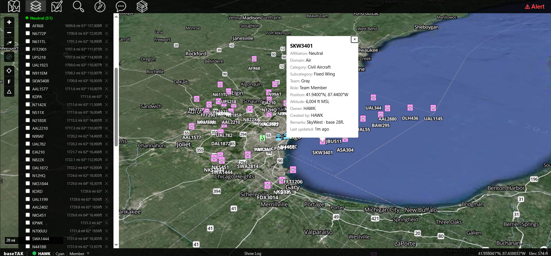
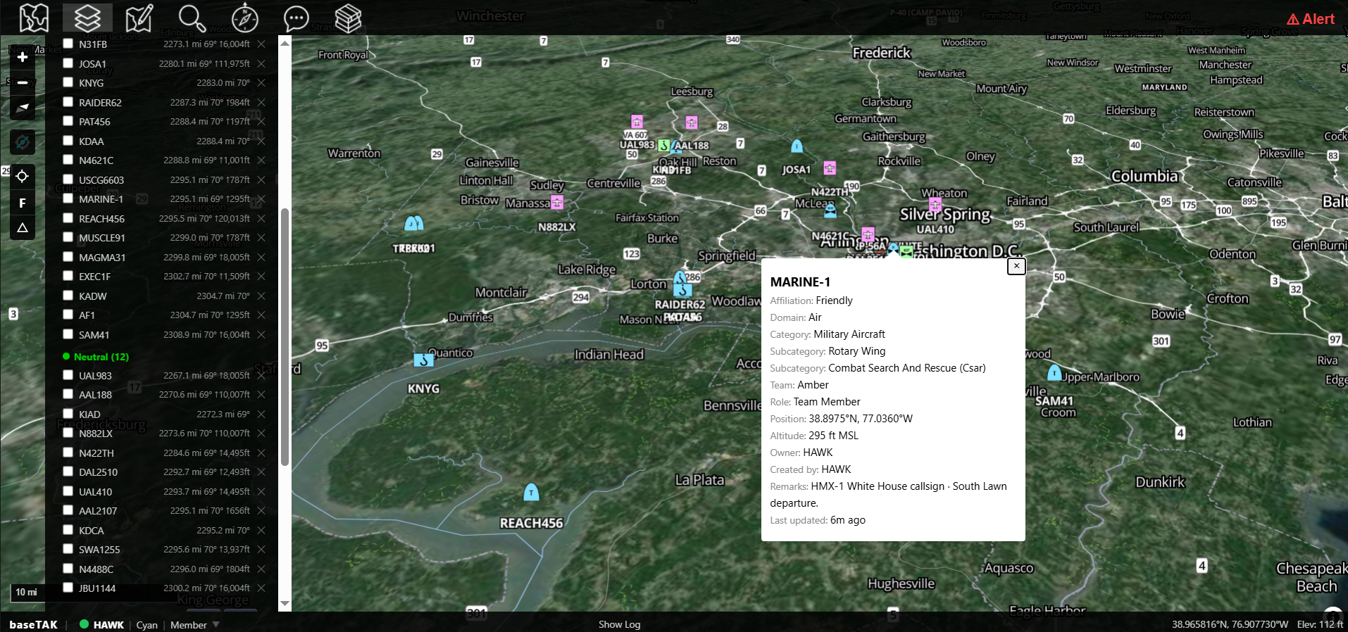
sdrTAK decodes the live ADS-B 1090 ES stream from the air around you and emits each aircraft as a native TAK contact. Paired with baseTAK, every aircraft shows up with the correct icon for its emitter category — and you can filter the map down to just the type you care about with a click.

  • Proper aircraft icons on the map — 14 ADS-B emitter categories mapped to 2525C/2525D symbology (fixed-wing heavy, light, rotorcraft, glider, lighter-than-air, etc.). Airliners look like airliners; helos look like helos.
  • Filter by aircraft type — baseTAK's map filter isolates the categories you care about. Only military traffic during a TFR, only rotorcraft during a SAR coordination, only heavies during airshow ops.
  • ADS-B 1090 ES decoding — the global civil aviation transponder standard.
  • UAT 978 MHz decoding — the U.S. general-aviation alternative (run alongside 1090 with a second dongle).
  • CPR position decoding — proper even/odd Mode S compact position reporting for sub-meter lat/lon accuracy.
  • 520k-entry aircraft database — auto-loads OpenSky CSV on startup, adds tail number, manufacturer, model, operator, and owner to every contact's remarks.
A baseTAK satellite-imagery view of Chicago O'Hare airspace dense with ADS-B aircraft contacts — arrivals on approach, departures climbing, GA traffic at the satellite airports — with a marker info card open for SkyWest 3401 (E175) and a left rail listing every contact
OUTCOME 02

Flag military and government aircraft automatically

sdrTAK ships with a built-in lookup table of ICAO hex ranges for U.S. DoD, Army, UK, France, and Germany, plus 25+ military callsign prefixes (RCH, FORTE, DUSTOFF, SAM, CGR, and others).

  • Military hex range detection — automatically marks aircraft in known DoD ranges.
  • Callsign prefix matching — RCH (military airlift), DUSTOFF (medevac), SAM (special air missions), and more.
  • Friendly affiliation flip — military contacts render with the friendly 2525C affiliation instead of neutral.
  • Extensible — add your own ranges and prefixes via settings.
A baseTAK 3D satellite view of the National Capital Region: civilian airliner contacts rendered in muted neutral symbology while military and government aircraft — MARINE-1, REACH456, RAIDER62, TREK01, SAM41, MAGMA31 — are highlighted with friendly affiliation symbology, with a marker info card open for MARINE-1
OUTCOME 03

Add the sea picture — and any other RF signal you can decode

The same architecture that handles ADS-B decodes any SoapySDR-driven radio stream.

  • AIS (162 MHz ship tracking) — for harbor, port, and coastal ops (decoder in tree; release imminent).
  • rtl_433 ISM-band sensors — for sensor-network integration (roadmap).
  • Add your own decoders — the SoapySDR abstraction means write-once decoder plugins work with any driver-supported hardware.
A rugged Windows laptop on a desk in a harbormaster's office, screen showing a TAK satellite map with AIS ship contacts marked across a busy California port. Through the window: real container ships, cranes, and a U.S. flag
OUTCOME 04

Drop sdrTAK on the LAN — air and sea show up in every TAK client

sdrTAK is 100% standalone — no shared code, database, or process with any other xTAK product. The only shared interface is the TAK network.

  • Aircraft and ships feed onto baseTAK alongside your operational markers.
  • Visible on every ATAK / WinTAK / iTAK client on the LAN.
  • Composes with digiTAK APRS stations and loraTAK mesh nodes on the same map — the full xTAK air / surface / ground picture from one TAK feed.
  • Per-decoder stale time — aircraft age out independently from ground unit positions.
A baseTAK 3D oblique view of Puget Sound combining four xTAK feeds on a single map: sdrTAK ADS-B aircraft and AIS vessels, digiTAK APRS stations, and loraTAK Meshtastic nodes, with a left rail grouping the contacts by Friendly and Neutral affiliation

What's in the box.

sdrTAK is a software-defined-radio listener that decodes ADS-B and UAT (with AIS shipping soon) into native TAK contacts. Plug in an RTL-SDR dongle and every aircraft in your area shows up on the TAK map with a full track, callsign, and identity.

★ Choose sdrTAK when

Airshow weekend. TFR overhead. The safety team needs to see every transponder in the air — not in a browser tab, in the ops picture. $30 dongle. One antenna. Every aircraft in the region.

☕ Beta · Early Access

Get sdrTAK in your hands now.

Become a supporter on Buy Me a Coffee and join the early-adopter Beta — get the current build, the next release, and direct engagement with the team.

Support on Buy Me a Coffee

What sdrTAK needs.

Hardware
Linux appliance or any Debian Bookworm / Ubuntu 22.04+ host
SDR dongle
RTL-SDR for 1090 (~$30), a second RTL-SDR for UAT 978, AirSpy R2 for better sensitivity, or HackRF. 13 SoapySDR drivers bundled — any SoapySDR-supported device works.
Antenna
Ground-plane or discone for 1090 / 978. AIS is 162 MHz — different antenna.
Network
A LAN — same one your ATAK / WinTAK clients are on
Installation
100% offline tarball · all .deb drivers, dump978-fa, and aircraft database vendored. No network access at install time.
Internet
Not required · aircraft database can pull updates if available
Aircraft database
520k-entry OpenSky CSV · auto-loads on startup · enriches every contact with tail number, type, operator, owner
Admin UI
Web, port 5100 · gain/stale-time, decoder enable/disable, device discovery, icon picker, DB refresh, restart
Version
v 1.4.0 (Beta · shipping soon · 65 passing tests)

Questions
operators ask.

Do I really only need a $30 dongle?

For ADS-B 1090 ES, yes. An RTL-SDR Blog v3 dongle (~$30) and a basic ground-plane antenna gets you every aircraft within roughly 100-150 nautical miles. Better antennas and higher-gain SDRs (AirSpy R2) extend the range.

Do I need internet?

No. The install runs without internet (everything is vendored). At runtime, the aircraft database stays current via optional periodic updates, but operation never requires it.

Will it flag military aircraft automatically?

Yes. Built-in lookup table covers U.S. DoD, Army, UK, France, German ICAO hex ranges, plus 25+ military callsign prefixes (RCH, FORTE, DUSTOFF, SAM, CGR, and others). Detected military aircraft flip to friendly 2525C affiliation. The lookup is extensible.

When is AIS shipping?

The decoder is in tree and the architecture is in place — AIS release is imminent. Early Adopters get it the moment it ships.

Can I add my own decoder for some other RF signal?

Yes. sdrTAK uses the SoapySDR abstraction — write-once decoder plugins work with any driver-supported hardware. rtl_433 (ISM-band sensors) is on the roadmap as an example.

Do I need TAK Server?

No. sdrTAK talks to TAK clients directly on the LAN.

Will my aircraft data leave my deployment?

No. Unlike pushing to commercial aircraft-tracking feeds, sdrTAK keeps your data on your hardware. Your antenna, your receiver, your data.